Groundwater Management Areas
Groundwater Management Areas
The Groundwater Management Area (GWMA) program focuses on assessing areas where groundwater problems from nonpoint source contaminants (such as agricultural chemicals) exist or are likely to exist. The Agency carries out detailed field studies to collect groundwater data, assesses the data, and determines whether a correlation exists between land use practices and any nonpoint contamination trends. The Department's conclusions and recommendations are presented at public hearings during which public comments on the study are also obtained.
The Director makes a determination on whether or not to designate the study area as a Groundwater Management Area. The staff works closely with the Natural Resources District(s) (NRDs) within whose boundary the area is located throughout the investigation, designation and implementation stages. The NRDs are responsible for implementation of many aspects of this program. In fact, NRDs can designate Groundwater Management Areas acting on their own authority. In addition to the three DWEE-designated areas, 20 NRDs have designated GWMAs within their jurisdiction.
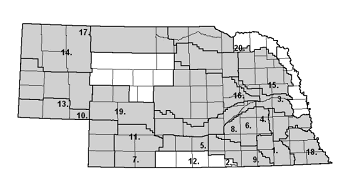
However, if an NRD does not implement a Groundwater Management Area, the Department has the responsibility of implementation. The Department reviews and comments on all proposed GWMA rules and regulations prior to public notice. The following map shows DWEE study areas (numbers) and existing GWMAs (shaded areas).

| DWEE GWNA Studies | |
|---|---|
| 1. Beatrice/DeWitt, 1988 | 11. N Middle Republican, 1995 |
| 2. Superior, 1988 | 12. Lower Republican, 1996 – 97 |
| 3. Fremont, 1988 | 13. E. Cheyenne Co., 1996 |
| 4. E. Upper Big Blue, 1989 | 14. Box Butte Co./Mirage Flats, 1998 |
| 5. Wilcox/Hildreth, 1989 | 15. S. Lower Elkhorn, 1999 |
| 6. York/Polk Co., 1990 | 16. E. Upper Loup, 2000 |
| 7. Red Willow/Hitchcock Co., 1990 | 17. E. Sheridan Co., 2001 |
| 8. W. Upper Big Blue, 1991 | 18. Humboldt, 2001 |
| 9. E Little Blue, 1992 – 94 | 19. Keith-Lincoln Co., 2002 – 03 |
| 10. Deuel Co., 1992 | 20. Bazile Triangle, 2004 |
