Sarpy County SID Board
May be slow to load depending on the number of documents
Legal Notice Below
=====================================================================
NOTICE OF INTENT TO CERTIFY – Section 401
NEBRASKA DEPARTMENT OF WATER, ENERGY, AND ENVIRONMENT
PLANNING & AID DIVISION
LINCOLN, NEBRASKA
In accordance with Section 401 of the federal Clean Water Act (33 U.S.C. Par. 1251 et seq.), certification that Title 117 – Nebraska Surface Water Quality Standards (Nebraska Administrative Code) will not be violated has been applied for to the Nebraska Department of Water, Energy, and Environment (DWEE) by the persons listed below for discharges requiring Federal permits or licenses.
The Sarpy County SID board has applied for a Section 404 permit from the U.S. Army Corps of Engineers (USACE) to conduct activities in Waters of the United States. The proposed project requires state Water Quality Certification in accordance with Clean Water Act (CWA) Section 401(a)(1), which states that:
Any applicant for a Federal license or permit to conduct any activity including, but not limited to, the construction or operation of facilities, which may result in any discharge into the navigable waters, shall provide the licensing or permitting agency a certification from the State in which the discharge originates or will originate, or, if appropriate, from the interstate water pollution control agency having jurisdiction over the navigable waters at the point where the discharge originates or will originate, that any such discharge will comply with the applicable provisions of sections 301, 302, 303, 306, and 307 of this title.
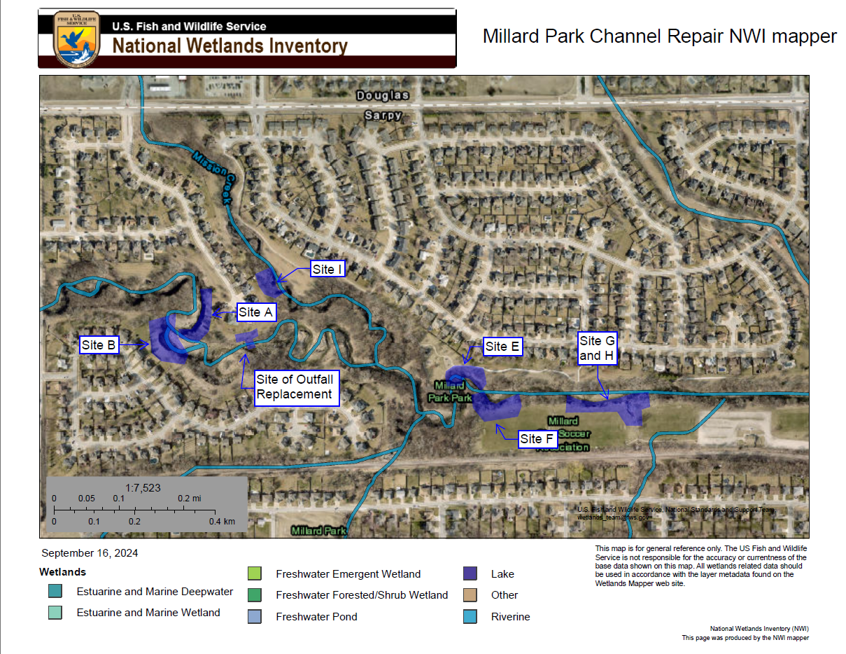
The Sarpy County SID Board is seeking to implement several bank stabilization measures along South Papillion Creek in Sarpy County, Nebraska. This project will be accomplished through work at six different sites, as described below…
Site A: This project will involve the installation of a sheet pile wall to correct stream bank
erosion and prevent further bank loss. The bank stabilization at Wetland Area 3 and Drainage
1 will be comprised of 155 LF, 28-foot-tall Skyline PZ22 or an approved equivalent steel sheet
pile wall. Approximately 12 feet of sheet pile will extend above the flowline elevation of
Drainage 1. Behind the sheet pile wall, a 3” polyethylene perforated underdrain pipe will be
installed to provide for drainage behind the wall. A minimum of 4 inches of Drain fill meeting
the requirements of Granular Backfill material described in the City of Omaha Standard
Specifications for Public Works Construction 2024, Section 305 will be placed below the
underdrain pipe, and the drain fill will extend towards the top of the sheet pile wall. A Mirafi
180N Geotextile fabric or approved equivalent will be placed between the drain fill and the
existing soil upslope of the improvements. Soil fill and topsoil obtained from uplands on-site
or off site will be placed on top of the drain fill and be shaped up the bank of Drainage 1 (South
Papillion Creek) to create a 2.5:1 slope. The disturbed area behind the sheet pile wall will be
seeded with Type B Seed Blend or an approved equivalent after construction activities are
complete. It is anticipated that this bank stabilization will permanently impact 0.007 acres of
Wetland Area 3 and 0.023 acres (171 LF) of Drainage 1. Previously approved under NWO-
2025-00304-WEH.
Site E: This project will involve the installation of a sheet pile wall to correct stream bank
erosion and prevent further bank loss. The bank stabilization at Wetland Area 6 and Drainage
1 will be comprised of 148 LF, 35-foot-tall Skyline PZ22 or an approved equivalent steel sheet
pile wall. Approximately 14.5 feet of sheet pile will extend above the flowline of Drainage 1.
Behind the sheet pile wall, a 3” polyethylene perforated underdrain pipe will be installed to
provide for drainage behind the wall. A minimum of 4 inches of Drain fill meeting the
requirements of Granular Backfill material described in the City of Omaha Standard
Specifications for Public Works Construction 2024, Section 305 will be placed below the
underdrain pipe, and the drain fill will extend towards the top of the sheet pile wall. A Mirafi
180N Geotextile fabric or approved equivalent will be placed between the drain fill and the
existing soil upslope of the improvements. Soil fill and topsoil obtained from uplands on-site
or off site will be placed on top of the drain fill and be shaped up the bank of Drainage 1 (South
Papillion Creek) to create a 2.5:1 slope. The disturbed area behind the sheet pile wall will be
seeded with Type B Seed Blend or an approved equivalent after construction activities are
complete. It is anticipated that this bank stabilization will permanently impact 0.000088 acres
of Wetland Area 6 and 0.020 acres (162 LF) of Drainage 1. Previously approved under NWO-
2025-00304-WEH.
Site F: This project will involve the installation of a sheet pile wall to correct stream bank
erosion and prevent further bank loss. The bank stabilization at Wetland Area 2 and Drainage
1 will be comprised of 118 LF, 35-foot-tall Skyline PZ22 or an approved equivalent steel sheet
pile wall. Approximately 14.5 feet of sheet pile will extend above the flowline of Drainage 1.
Behind the sheet pile wall, a 3” polyethylene perforated underdrain pipe will be installed to
provide for drainage behind the wall. A minimum of 4 inches of Drain fill meeting the
requirements of Granular Backfill material described in the City of Omaha Standard
Specifications for Public Works Construction 2024, Section 305, will be placed below the
underdrain pipe, and the drain fill will extend towards the top of the sheet pile wall. A Mirafi
180N Geotextile fabric or approved equivalent will be placed between the drain fill and the
existing soil upslope of the improvements. Soil fill and topsoil obtained from uplands on-site
or off-site will be placed on top of the drain fill and be shaped up the bank of Drainage 1 (South
Papillion Creek) to create a 2.5:1 slope. The disturbed area behind the sheet pile wall will be
seeded with Type B Seed Blend or an approved equivalent after construction activities are
complete. It is anticipated that this bank stabilization will permanently impact 0.017 acres of
Wetland Area 2 and 0.016 acres (102 LF) of Drainage 1.
Site G: This project will involve the installation of a sheet pile wall and rip rap to correct stream
bank erosion and prevent further bank loss. The bank stabilization at Wetland Area 1 and
Drainage 1 will be comprised of 354 LF, 35-foot-tall Skyline PZ22 or an approved equivalent
steel sheet pile wall. Approximately 14.5 feet of sheet pile will extend above the flowline of
Drainage 1. Behind the sheet pile wall, a 3” polyethylene perforated underdrain pipe will be
installed to provide for drainage behind the wall. A minimum of 4 inches of Drain fill meeting
the requirements of Granular Backfill material described in the City of Omaha Standard
Specifications for Public Works Construction 2024, Section 305, will be placed below the
underdrain pipe, and the drain fill will extend towards the top of the sheet pile wall. A Mirafi
180N Geotextile fabric or approved equivalent will be placed between the drain fill and the
existing soil upslope of the improvements. Soil fill and topsoil obtained from uplands on-site
or off-site will be placed on top of the drain fill and be shaped up the bank of Drainage 1 (South
Papillion Creek) to create a 3:1 slope. The disturbed area behind the sheet pile wall will be
seeded with Type B Seed Blend or an approved equivalent after construction activities are
complete. Rip rap placement will also be included in this project area within Wetland Area 1
and Drainage 1, downstream of a storm sewer outfall, to correct ditch erosion and prevent
further incising. A 4-inch layer of 1” screened limestone aggregate bedding material will be
initially placed in accordance with City of Omaha Standard Specifications for Public Works
Construction 2024, Section 805. A 3-foot layer of Type C Rock Rip Rap will be placed over
top. The rock layers will be underlain by Mirafi 180N Geotextile Fabric or approved
equivalent. The channel slopes beyond the rip rap will be seeded with a Channel Seed Blend
following the completion of work. It is anticipated that this bank stabilization will permanently
impact 0.052 acres of Wetland Area 1 and 0.149 acres (520 LF) of Drainage 1.
Site I: This project will involve the installation of a storm sewer line and an area inlet, along
with bank stabilization to repair erosion. The area inlet construction at Wetland Area 5 and
Drainage 1 will be comprised of a single 24-inch diameter High-Density Polypropylene
(HDPP) Storm Dual Wall culvert pipe with a length of 35 feet with a 24-inch diameter
Nyloplast round top area inlet. The area inlet is intended to capture concentrated flows from
the surrounding homes and discharge them towards Drainage 1 via the culvert, preventing
concentrated flows from further eroding the banks. The area inlet and storm sewer pipe will
not impact any wetlands or Waters of the U.S. A 6-foot long, 24-inch diameter High-Density
Polyethylene (HDPE) flared end section will extend from the end of the storm sewer pipe into
Wetland Area 5 and Drainage 1. Downstream of the storm sewer pipe, excavation will occur
to repair erosion along Drainage 1. Approximately 40 CY of Type B rip rap will be placed
within Wetland Area 5 and Drainage 1. It is anticipated that this rip rap placement will
permanently impact 0.005 acres of Wetland Area 5 and 0.008 acres (32 LF) of Drainage 1.
Previously approved under NOW-2025-00304-WEH.
Site of Outfall repair: This project will involve storm sewer outlet repair, which includes the
removal and relocation of a Timber Pile structure, removal of 16’ of 18” RCP, and the
installation of a scour basin to prevent further bank loss. The outfall repair at Drainage 1 will
comprise of the removal of a single 16-foot by 18-inch diameter reinforced concrete pipe storm
pipe that has fallen into the drainage and the associated two 12-inch diameter Timber Pile.
Once all previous structures have been removed, two 12-inch diameter Timber Pile will be
driven at a minimum of 15 feet deep below the existing outfall of the storm sewer. Drainage 1
below the outfall pipe will be excavated to install a Scour Basin to prevent further erosion of
the banks and bottom of the drainage. Approximately 14.4 square yards of Geotextile Fabric
will be placed at the bottom of the Scour Basin, and then approximately 17 cubic yards of Type
C Rip Rap in a 13-foot by 11-foot Scour Basin that is 3.2 feet thick will be installed. It is
anticipated that this rip rap placement will permanently impact 0.002 acres (11 LF) of Drainage
1. During the installation of the Scour Basin, approximately 0.012 acres (23 LF) of the channel
will be temporarily impacted for temporary construction access and work.
The proposed certification and supporting materials are available for inspection at the office of DWEE, 245 Fallbrook Blvd, STE 100, Lincoln, Nebraska. Persons may comment upon or object to the application, by submitting written comments within 30 days after this publication date of this notice. Comments should be limited to the scope of state Water Quality Certification (WQC) under Section 401 of the CWA. During this period, persons may request a public hearing. A request for a hearing must state the nature of the issues to be raised and all arguments and actual grounds supporting such position. Such comments shall be considered prior to making a final decision regarding the request. Any comments or requests should be submitted to:
CWA Section 401 Coordinator
Nebraska Department of Water, Energy, and Environment
245 Fallbrook Blvd, Suite 100
Lincoln, NE 68521
-or-
ndwee.401certification@nebraska.gov
Please notify DWEE in advance if alternate formats of documents are needed. Our switchboard phone number is 402-471-2186. TDD users please call 711 and ask the relay operator to call us at 402-471-2186.
=====================================================================